Eastern States, Middle
Kentucky
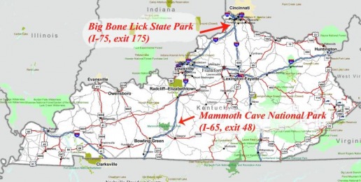
B, H, C. I-65, exit 48. Park at the Shell truck stop. Mammoth Cave National Park. Head up the road and the trail is off to the right (about a mile from the Shell station, less maybe). The trail is packed gravel, with a few hills so steep yellow downgrade signs are posted warning that you must dismount. (It wasn’t photo-enforced so I risked it, and lived. But, be careful – there are no runaway bike ramps.) The visitor center & main cave entrance is nine miles in and from there you can purchase tour tickets. I took the short, free tour. The tour guides are Park Rangers so they’ll try their damndest to teach you something – be careful.
B. I-75: exit 175. Park at Pilot (either), or TA. Who could pass up a place named, “Big Bone Lick State Park.” Turns out I’m in good company: William Clark (sans Lewis) is credited with birthing American paleontology there. Mr. Clark applied his scientific methods to wooly mammoth bones discovered at Big Bone Lick. The park is six miles from the truck stops, up and down rolling two lane roads. Pastoral stuff. Many pastorals. (Kentuckians love their grass, maybe more so than Californians.) I’m not much for road rides, but the horse farms, birds (cardinals, blue-colored birds, yellow-colored birds – I’m a bird buff), a couple of deer sightings, few historical markers and perfectly balanced hills kept me thoroughly entertained. Go west on Richwood road (aka, KY 338) and follow KY 338 signs until you get to the park.
B. I-75: exit 175. Park at Pilot (either), or TA. Who could pass up a place named, “Big Bone Lick State Park.” Turns out I’m in good company: William Clark (sans Lewis) is credited with birthing American paleontology there. Mr. Clark applied his scientific methods to wooly mammoth bones discovered at Big Bone Lick. The park is six miles from the truck stops, up and down rolling two lane roads. Pastoral stuff. Many pastorals. (Kentuckians love their grass, maybe more so than Californians.) I’m not much for road rides, but the horse farms, birds (cardinals, blue-colored birds, yellow-colored birds – I’m a bird buff), a couple of deer sightings, few historical markers and perfectly balanced hills kept me thoroughly entertained. Go west on Richwood road (aka, KY 338) and follow KY 338 signs until you get to the park.
Tennessee
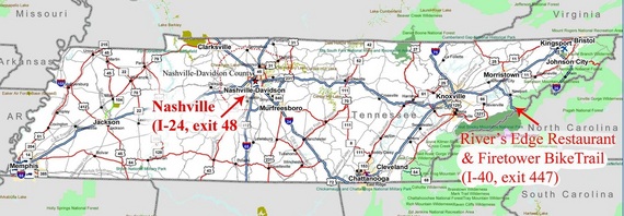
D. I-40: exit 447. Park at the “Downtown Hartford Citgo.” (“Downtown” Hartford consists of two gas stations, a restaurant, and a couple of seasonal rafting outfitters. The off-ramp nearly runs through The Downtown Hartford Citgo.) Due to a flat tire I’m writing up a restaurant. An espresso shop/hamburger joint. Whatever works. But, it has a nice deck with a view of the Pigeon River, occasional wildlife, and raft-loads of bright orange tourists. The majority of folks opt for rafting, which does save time and money (2 hours, about 40 bucks versus 4-5 hours and 150 bucks). Hartford sits on the Pigeon River, surrounded by the Cherokee National Forest, and a stones-throw from the Great Smokey Mountain National Park and Appalachian Trail. The plan was to find the Appalachian trail, but fate decided a flat tire midway there would be funny. Plan B waskayaking, but fate talked me into calling an hour too late, “would you like to make a reservation for tomorrow?” Uh, no. So, I sulked at the River’s Edge Café (I think that’s what their sign reads). Pleasant little oasis from the trucking community. So, from the “downtown” truck stop head under the freeway and the café is at the “T,” a block & a half maybe.
UPDATE: ACROSS THE STREET FROM THE TRUCK STOP IS THE ROAD TO THE MOUNTAIN BIKE TRAIL! Duh. Third time’s a charm. I guess locals drive to the top, but only about a mile up Mill creek road is the state forest and trail. Not very strenuous to get to either. The trail cuts across a few streams where stones strategically break the surface. Tree debris carpets the trail for a nice muffled effect. Very cool trail. Very accessible.
B, H, D, C. I-24, exit 48. Park at the TA (and be sure to check out their flood pictures in the hallway). Nashville is about the easiest city of size (it’s a big city, but I don’t want to offend) to explore. For less than $7.00 you can take a cab from TA to Music Row. (But, if you absolutely insist on stiffing the locals it’s probably only a 10 minute walk, if you drag your feet.)There you’ll find plenty of restaurants, western wear stores (for riding into the sunset at the end of your visit) clubs, and, of course, music. Our cabbie (himself a veteran long haul driver) recommended Merchants for dining. We shared our meals, one of which was a Fried green tomato BLT. Excellent. If you’re looking for women, they’re all trying on boots. Really. Apparently they all think there’s a shitstorm coming. Anyway, the honky tonk we settled on played to the crowd, and was very entertaining. As I mentioned, a microphone was offered and we obliged. Fun times. So, to get there: amble out of the TA in a westerly direction.
